
Proximity Fitting
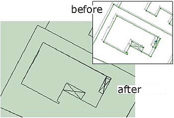
The pictures show the steps in proximity fitting using Systra in the field of utility line cadastre. Most energy providing companies have their own digital geometric documentations and to adjust them to base coordinate systems.
For example the German automated land registration map will become the geo base system for many secondary users like water and energy providers or traffic companies. They have to fit their own digital maps to the base coordinates.
Here the power of Systra is based on a strategy of proximity fitting that maintains geometric conditions like straightness and parallelism. The strategy is supported by an automated procedure to find point identities within different maps and geometric conditions. By combining these single functions the Systra method becomes not only correct but also very efficient.