


Visit us at the Intergeo 2025 in Frankfurt am Main, Germany. Our experts for the products Scantra and Systra are looking…
zum ArtikelBenefits
Efficiency Scantra works solely on redundantly captured regions within acquired scans and hence does not require artificial targets in the scene. By this, the time on site is significantly reduced since the effort to distribute, document and survey targets is obsolete. In addition, Scantra is capable to handle targets that are for instance used to transform a registered point cloud into a superior coordinate system. A tedious task in processing large projects is to identify blunders that occurred during registration. For this sake, Scantra offers an efficient blunder detection algorithm that allows localising the corresponding observations.
Precision In contrast to cloud-to-cloud approaches, such as the iterative closest-point algorithm (ICP), Scantra establishes plane-to-plane correspondences. This approach notably reduces effects provoked by the sampling uncertainty. In addition, the error budget notably enhances since adjusted plane parameters are far more precise than single points.
Performance Scantra uses a high-performance database system that allows handling data even from several thousand scans. By using plane parameters instead of points the data volume drastically decreases: a project with 368 scans requires 19.86 GB (binary files) of storage while the Scantra database only occupies 265 MB of memory. This capability allows to process very large projects with off-the-shelf hardware.
Transparency Quality assurance (QA) is a vital task in every project and equally important for your own organisation as well as your customer. The final step of every Scantra project is a block adjustment that considers the information from all stations and yields in an optimal solution – independent to any calculation sequence. Scantra provides established and transparent quality measures that are well known from adjustment calculus and form a sound base for your QA deliverables. Apart from detailed numerical reports based on the adjustment a graphical user interface supports the user in interpreting the outcome.
The Scantra workflow
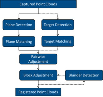
1. Import point clouds
2. Automatic detection of planes in each scan (optional: target detection)
3. Determination of adjacent scans and pairwise registration based on:
- an automatic plane matching process, or if required
- a manual pre-alignment followed by automatic plane matching
4. Block adjustment of all scans into a common target system, either
- into a local reference system of a master scan
- a user-defined reference frame
- or a superior geodetic coordinate system
Optionally, a blunder detection algorithm can be initiated.
5. Application of highly precise and reliable registration parameters to all scans
Features
Supported formats
| File format | File import | File export | Updating registration parameters | Remarks |
|---|---|---|---|---|
| *.e57 | x | x | By overwriting header entries | |
| *.las / *.laz | x | x | Not supported | |
| Faro: *.fls | x | - | Not supported | Access via Faro Scene project |
| Faro: *.lsproj | x | - | By writing a new revision via the Faro Scene API | |
| Leica: *.pts | - | x | Not supported | |
| Leica: *.ptx | x | x | By overwriting header entries | |
| LupoScan: *.lps | x | - | By overwriting header entries or via *.lps.ori | |
| OpenScanTools: *.tls | x | x | Not supported | |
| PointCab: *.lsd | x | - | Not supported | Access via PointCab Origins project |
| PointCab: *.pcp | x | - | By overwriting the orientation file *.lsdx | |
| Riegl: *.rdbx | x | - | Not supported | |
| Riegl: *.rsp | x | - | By overwriting the project file *.rsp | |
| *.xyz | - | x | Not supported | |
| Zoller + Fröhlich: *.zfprj | x | - | Not supported | |
| Zoller + Fröhlich: *.zfs | x | - | By overwriting header entries |
Registration
- Plane-based
- Target-based
- Plane and target-based
- Block Adjustment (planes and / or targets)
- Images-based pre-alignment (planes and / or points)
- Application of pre-orientation (requires direct georeferencing or similar)
Reporting & Quality Assurance
- Pairwise Registration: Residuals, partial redundancies and normalised residuals between roints and / or planes
- Pairwise Registration: Visualise matched planes
- Pairwise Registration: Horizontal section
- Block Adjustment: Adjusted registration parameters of stations including standard deviations
- Block Adjustment: Residuals and partial redundancies for observation groups and individual observations
- The Inspector: Browser Window with observations that feature the ten largest normalised residuals
Scantra Case studies
The true capability of every software shows when it is used within practical projects. This section features selected case studies by some of our customers and co-operation partners.
- Zoller + Fröhlich, Wangen, Germany: Efficient documentation of a castle
- Z&M 3D WELT: Plane-based registration of several thousand laser scans on standard hardware
- 3D-Welt: Mapping an Operational Medical Clinic in 3D with ~13,000 scans
Latest Scantra news and events
We're delighted to announce that Scantra 3.4 Static, Kinematic and Polar can be downloaded from our server. Detailed inf…
zum ArtikelWe're delighted to announce that Scantra 3.3 KINEMATIC, PRO and LT can be downloaded from our server. Detailed informati…
zum ArtikelWe're delighted to announce that Scantra 3.2 PRO and LT can be downloaded from our server. Detailed information about th…
zum ArtikelWe're delighted to announce that Scantra 3.0 PRO and LT can be downloaded from our server. Detailed information about th…
zum Artikel
Visit us at the Intergeo 2022 in Essen, Germany. Our experts for the products Scantra and Systra look forward to your vi…
zum Artikel